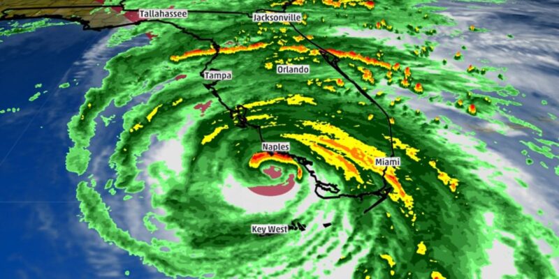
After breaking numerous weather records along its path, Hurricane Irma made its final landfall on September 10th in Collier County, Florida, the headquarters of Gulf Western Roofing. The storm ran straight up the spine of Florida after that, affecting nearly everyone affiliated with GWR to some degree: our employees and their families, our vendors, our trade partners, and our customers.
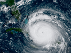
[Image: Wikimedia Commons]
Irma’s effects varied across the state as a result of location and chance. For instance, though the storm made a double landfall in both the Keys and Southwest Florida, the hurricane’s heaviest rainfall (15.91″) was recorded in Ft. Pierce, a town on the state’s east coast fairly far from the center of Irma’s passage. Meanwhile, Irma’s most widespread rains were far to the northeast around Jacksonville, hundreds of miles from the storm’s landfall.
If the roof of your home or business received damage from Hurricane Irma, we’d like to help you. Click on this link to be taken to our online service request form on our website. There you can tell us about your issue, and we can together start the process of making your roof right again. And please feel free to tell any of your friends or family members who were also affected. We’re Florida’s premier residential roofer for a reason.
WIND SPEEDS
Using a number of different sources (noted below), we’ve put together a list of wind speeds measured around Florida. (Note that while most of these numbers are from official sources, they should still be considered preliminary until Hurricane Irma’s full Tropical Cyclone Report is released by the National Hurricane Center sometime over the next several months.)
Southwest Florida (headquarters of Gulf Western Roofing) and parts of the Keys saw the strongest gusts. Here’s a selection of some of the highest from around the area:
- Naples Airport (Collier County): 142 mph
- Marco Island: 130 mph (Collier)
- Lely (Collier): 122 mph
- Big Pine Key (Monroe): 120 mph
- Ochopee (Collier): 96 mph
- Bonita Springs (Lee): 93 mph
- Key Largo (Monroe): 92 mph
- Key West (Monroe): 91 mph
- Ave Maria (Collier): 89 mph
- Marathon Key (Monroe): 88 mph
- Fort Myers Southwest Florida International Airport (Lee): 89 mph
- Fort Myers Page Field (Lee): 84 mph
- Port Charlotte (Charlotte): 74 mph
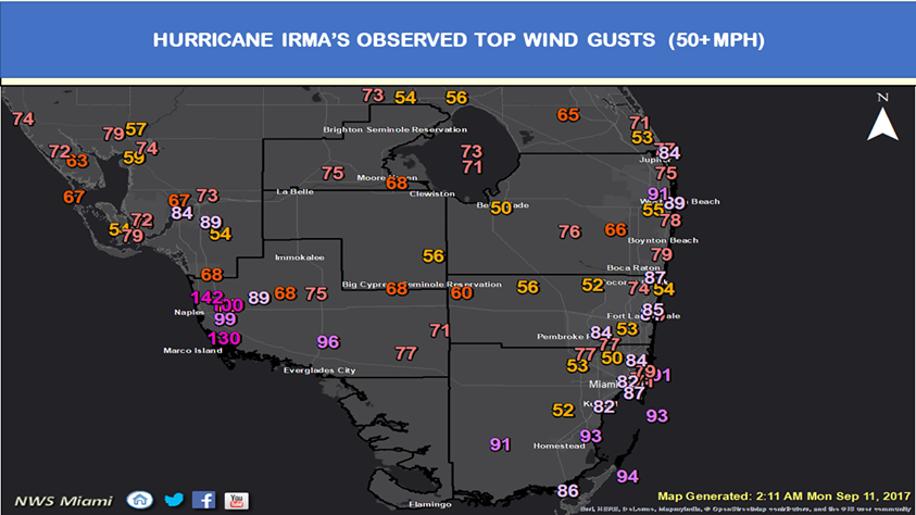
[Image: NWS Miami]
- North Perry Airport (Broward): 109 mph
- Miami International Airport (Miami Dade): 99 mph
- St. Lucie Nuclear Power Plant (St. Lucie): 99 mph
- Cape Canaveral (Brevard): 94 mph
- Coral Gables (Miami Dade): 90 mph
- Deerfield Beach (Broward): 86 mph
- Miami-Opa Locka Executive Airport (Miami Dade): 84 mph
- Flagler Beach (Flagler): 83 mph
- Miami NWS/NHC office (Miami Dade): 81 mph
- Clearwater Beach (Pinellas): 79 mph
- Tampa Bay (Hillsborough): 78 mph
- Sebring (Highlands): 78 mph
- West Palm Beach International Airport (Palm Beach): 77 mph
- Fort Lauderdale/Hollywood International Airport (Broward): 75 mph
- Jacksonville International Airport (Duval): 75 mph
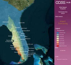
[Oasis / Aon Benfield ]
It’s also important to keep in mind that wind speeds experienced at a particular location can be dramatically enhanced by that location’s proximity to other buildings, trees, etc. At any given moment, wind blows at different speeds in different places; these varying wind speeds create rotational vortices, differential uplift, and suction forces, all interacting with one another and making the wind exponentially more destructive in places as winds increase to catastrophic levels. This is the reason one particular home may exhibit little in the way of cosmetic damage, while a similar home just a very short distance away may have suffered catastrophic damage. A single wind speed can result in many different pressure coefficients on a single structure at any given time, and that phenomenon is further exacerbated by wind speeds and directions changing constantly as a storm moves through an area.
Even further enhancing building damage in a hurricane is the presence of wind-borne debris. Loose ground materials, tree branches, commercial signs, pieces of dislodged building components, and the like can be torn loose, lifted up, and thrown several hundred feet before impacting neighboring structures. Almost all building envelope materials, including roof coverings, are at risk for impact damage from these high-energy projectiles. And maybe worst of all, the culprit will often be blown away after impact, leaving you as a homeowner wondering just why your roof is such a mess.
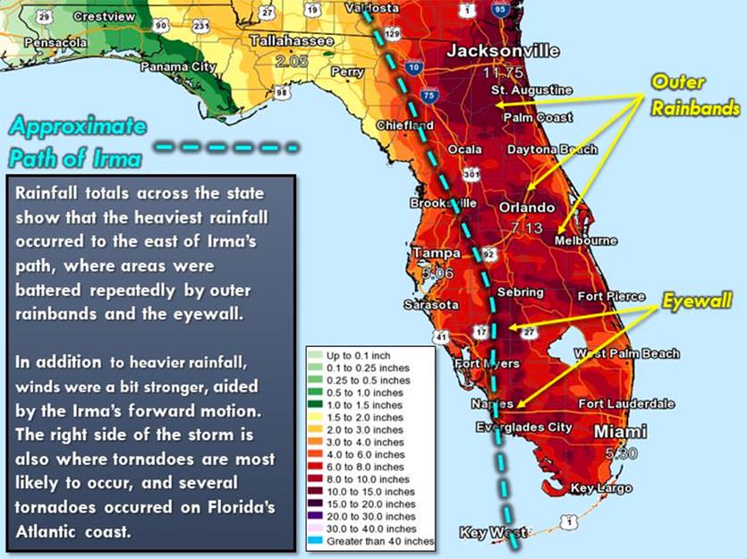
RAINFALL AMOUNTS
In addition to powerful, roof-destroying winds, Hurricane Irma also dumped some extreme rains over a very short period. The hurricane never stalled over Florida (as Hurricane Harvey did over Texas just a few weeks earlier), or rainfall amounts would have been higher still. Here are a few selected amounts from around the state:
- St. Lucie County International Airport (St. Lucie): 15.91″
- Oviedo (Seminole): 14.76″
- Gainesville (Alachua): 12.22″
- Naples (Collier): 11.74″
- Jacksonville (Duval): 11.17″
- University of Florida (Alachua): 10.42″
- Golden Gate Estates (Collier): 10.41″
- Southwest Florida International Airport (Lee): 10.33″
- Okeechobee County Airport (Okeechobee): 9.65″
- Orlando/Sanford Airport (Seminole): 9.42″
- Orlando (Orange): 7.68″
- Daytona Beach Airport (Flagler): 5.86″
- Miami Beach (Miami Dade): 3.95″
[Image: NWS Tampa Bay]
As we said earlier, we’re here to help. If your home or business received roof damage from Hurricane Irma, please give us a call, or click on this link to be taken to our online service request form. Tell us about your issue, and we can together start the process of making your roof right again. We’d like the opportunity to show you why we’re known as Florida’s premier residential roofer.
DATA SOURCES
Post Storm Hurricane Report (National Weather Service – Miami)
Hurricane Irma Recap (The Weather Channel)
Lake Okeechobee Nears Highest Water Level in 10 Years (Weather Underground)
Here’s how much rain, wind Irma brought to Florida (New Orleans Times-Picayune)
How much rain fell and how high the wind gusted on the US mainland during Hurricane Irma’s destruction (Business Insider)
Hurricane Irma (Wikipedia)
Sampling Errors in Estimation of Extreme Hurricane Winds (American Society of Civil Engineers [ASCE] – Civil Engineering Database)
5 False Wind Statements Debunked by an Expert Storm Engineer (Engineering Express)
Hurricane Winds at Landfall (Hurricane Science)


